Competency 4 – Knowledge of Earth and the processes that affect it
1. Relate surface and subsurface geologic processes to the movement of tectonic plates.
- Geology – the study of Earth, the materials of which it is made, the structure of those materials, and the processes acting upon them
- Geologic Processes – involve interactions of the atmosphere, biosphere, cryosphere, hydrosphere, and lithosphere; all types of processes affecting geologic structure
- Surface geologic processes – processes affecting geologic structure on the surface of Earth
- Erosion – the movement of rock fragments through gravity, wind, rain, rivers, oceans, and glaciers
- Detachment → transportation → deposition
- Physical weathering – the wearing down or breaking of rocks while they are in place
- Exfoliation – the breaking of rocks due rapidly changing temperatures
- Freeze-thaw – the breaking down of rocks caused by water in cracks expanding during freezing
- Abrasion – the breaking apart of rock caused by the blowing of sand and silt in wind
- Root expansion – the breaking apart of rock caused by root growth
- Chemical weathering – the wearing down or breaking of rocks caused by chemical reactions
- Carbonation – the dissolving of softer rocks by carbonic acid, formed when water reacts with carbon dioxide
- Dissolution – limestone and rocks with high salt content dissolve when exposed to water
- Hydrolysis – minerals in rock react with water and surrounding acids
- Oxidation-reduction – water and rock particles react with oxygen; causes rust
- Deposition – the laying down of sediment carried by wind, water, or ice
- Erosion – the movement of rock fragments through gravity, wind, rain, rivers, oceans, and glaciers
- Subsurface geologic processes – processes affecting geologic structure that occur below Earth’s surface
- Tectonic processes – subterranean movements that explain the formation of major landforms; movement of the tectonic plates
- Tectonic plate – a massive, irregularly shaped slab of solid rock, generally composed of both continental and oceanic lithosphere; also called lithospheric plates; form different types of boundaries:
- Divergent boundaries – plates that are moving apart; where new oceanic crust is created from magma; most divergent boundaries are located at the oceanic ridges
- Convergent boundaries – plates that are moving together; three types:
- Ocean-ocean – one of the plates is pushed (subducted) under the other; often the older and colder plate is denser and subducts under the younger, hotter plate; commonly an ocean trench along the boundary
- Ocean-continent – the oceanic plate is pushed under the continental plate; creates mountain chains with many volcanoes
- Continent-continent – colliding continental material will not be subducted as it is too light; tremendous deformation of the pre-existing continental rocks and mountains are created
- Transform boundaries – plates that are moving side by side without the production or destruction of crustal material
- Tectonic plate – a massive, irregularly shaped slab of solid rock, generally composed of both continental and oceanic lithosphere; also called lithospheric plates; form different types of boundaries:
- Tectonic processes – subterranean movements that explain the formation of major landforms; movement of the tectonic plates
- Surface geologic processes – processes affecting geologic structure on the surface of Earth
2. Trace the development of the theory of continental drift to the current theory of plate tectonics.
- Theory of continental drift (Alfred Wegener, 1912) – theory that continental landmasses were “drifting” across the Earth, sometimes plowing through the oceans and into each other
- Was convinced that all of Earth’s continents were once a part of an enormous single landmass called Pangaea and drifted apart over millions of years
- Resurfacing of continental drift (1960s) – technologies adapted from warfare made it possible to more thoroughly study Earth; included seismometers (used to monitor ground shaking caused by nuclear testing) and magnetometers (used to detect submarines)
- Seismometers – researchers discovered that earthquakes tended to occur in specific places
- Magnetometers – found evidence of magnetic variations near undersea ridges, alternating stripes of rock recorded a flip-flopping of Earth’s magnetic field
- Theory of plate tectonics – Earth’s crust is broken into roughly 20 sections (tectonic plates) on which the continents ride; built on the theory of continental drift by explaining how the continents move
- Earth has a rigid outer layer (lithosphere) which lies over a partially molten layer (asthenosphere)
- The lithosphere is broken up into tectonic plates
- Tectonic plates slowly shift due to motion in the asthenosphere
3. Relate the characteristics of geologic structures to the mechanisms by which they are formed.
- Geologic structures – usually the result of tectonic forces that occur within the Earth which fold and break rocks, form deep faults, and build mountains
- Primary structures – structures formed at the same time as the rocks in which they are found
- Beds and laminae in sedimentary rocks like sandstone or shale
- Lava pillows in extrusive igneous rocks like basalt
- Secondary structures – formed long after the rocks in which they are found
- Folds – ductile rocks behave plastically and become folded in response to stress
- Anticlines – parallel beds of the same rock type that dip away from the center of the fold; form in sections of the crust that are undergoing compression
- / \
- Synclines – parallel beds of the same rock type that dip toward the center fold; form in sections of the crust that are undergoing compression
- \ /
- Basins – a bowl like depression in the strata; similar to a syncline but with a single point at the center
- Dome – a bulge in strata; similar to an anticline but with a single point at the center
- Anticlines – parallel beds of the same rock type that dip away from the center of the fold; form in sections of the crust that are undergoing compression
- Fractures – mechanical breaks in rocks involving discontinuities in displacement across surfaces or narrow zones
- Dilating fractures (joints) – two rough surfaces that have moved away from each other in a direction perpendicular to the surfaces (mode I)
- Shearing fractures (faults) – shear displacement discontinuities where the fracture surfaces predominantly move parallel to each other; either perpendicular (mode II) or parallel (mode III) to the fracture front
- Closing fractures (pressure solution surfaces) – fractures in sedimentary rocks that are welded together by solution that occurs at the contact surfaces of grains
- Foliations – any sot of fabric-forming planar or curved planar geologic structure in a metamorphic rock; could also include sedimentary bedding or magmatic layering
- Primary foliations – key sources in the creation of buckle folds; form during the deposition of sediments and formation of magmatic rocks
- Secondary foliations – include axial plane cleavages; form in metamorphic rocks
- Folds – ductile rocks behave plastically and become folded in response to stress
- Primary structures – structures formed at the same time as the rocks in which they are found
4. Identify the evidence used to define geologic eras (e.g., geologic events, biotic factors, abiotic factors).
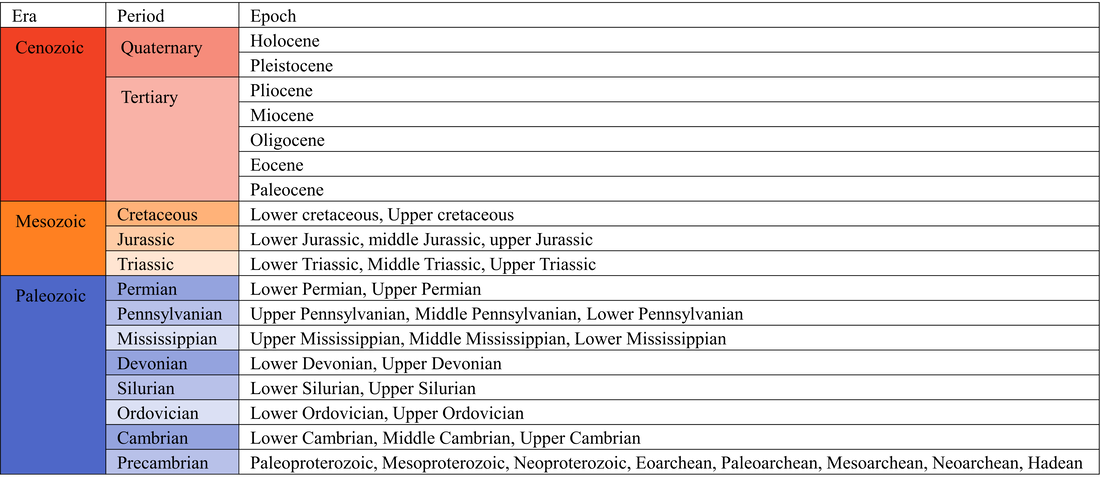
- Precambrian Time – 4.6 billion years ago to 541 million years ago
- Geologic events –
- Hadean – formation of the solar system
- Archean – continental shield rock began to form; Approximately 70% of continental landmass was formed during this time
- Proterozoic – plate tectonics; formation of Rodinia
- Biotic factors –
- Hadean – no life
- Archean – life began in the oceans (microscopic prokaryotic chemoautotrophs)
- Proterozoic – different types of prokaryotic organisms formed symbiotic relationships; photosynthesis began to add oxygen to the atmosphere, first multicellular organisms
- Abiotic factors –
- Hadean – frequent asteroid collisions
- Archean – reducing atmosphere of methane, ammonia, and other gases; water condensed in the atmosphere and filled the first oceans
- Proterozoic – brief ice age
- Geologic events –
- Paleozoic Era –
- Geologic events –
- Cambrian – Rodinia fragmented into Gondwana and smaller continents
- Ordovician – Gondwana moved farther south; smaller continents moved closer together
- Silurian – landmasses that would become North America and Europe moved closer together; rise in sea levels forming shallow inland seas
- Devonian – northern landmasses continued merging (Euramerica); Gondwana still exists
- Permian – Euramerica and Gondwana merge forming Pangaea
- Biotic factors –
- Cambrian – evolution of arthropods and chordates
- Ordovician – abundance of marine invertebrates (including the trilobite)
- Silurian – jawless fish, mollusks, and coral; first undisputed evidence of terrestrial life; evolution of plants
- Devonian – ferns; first trees; first land vertebrates (tetrapods); first land-living arthropods
- Carboniferous – ancestors of conifers; dragonflies; marine reptiles; archosaurs; cockroaches
- Permian – nautiloids and ammonoids; modern conifers and ginkgo trees; terrestrial vertebrates evolved to become herbivores; mass extinction (wiped out 96% of marine life and 70% of terrestrial species)
- Abiotic factors –
- Cambrian – warm weather
- Ordovician – ice age; formation of glaciers; lower sea levels
- Silurian – higher sea levels; shallow inland seas
- Geologic events –
- Mesozoic Era –
- Geologic events –no polar ice caps; large deserts; Pangaea
- Biotic factors –
- Triassic – reptiles; first dinosaurs
- Jurassic – birds and mammals
- Cretaceous – triceratops, Pteranodon; flowering plants; mass extinction
- Abiotic factors – much warmer than present day; major temperature swings; spike in carbon dioxide due to volcanic eruptions; global warming
- Cretaceous – asteroid impact causing mass extinction
- Cenozoic Era –
- Geologic events –
- Tertiary – continents drifted apart
- Quaternary – glaciers covered central North America; formation of the Alps, Himalayas, and the Rocky Mountains
- Biotic factors – “age of mammals”
- Tertiary – rodents and small horses are common; rhinos and elephants appear; dogs, cats, and pigs become commonplace; large flightless birds thrived; early primates (including humans); bovids; forests across North America
- Quaternary – cave lions; cave bears; saber-toothed cats, giant deer, woolly rhinos, wooly mammoths; forests died off as the climate cooled; savannas covered the middle of the continent; flowering plants and edible crops (cultivated by humans)
- Abiotic factors –
- Tertiary – global climate much warmer than present day; climate was much more consistent; global warming
- Quaternary – climate cooled, oceans widened
- Geologic events –
5. Apply methods for determining geologic age (e.g., law of superposition, radioactive decay, relative dating).
- Law of superposition – within a sequence of layers of sedimentary rock, the oldest layer is at the base and that the layers are progressively younger with ascending order in the sequence
- Absolute dating – methods of dating that involve measuring the physical properties of an object itself and using these measurements to calculate its age
- Radioactive decay – radioactive atoms trapped inside igneous rocks decay at a predictable rate; by measuring the quantity of these unstable atoms and comparing it to the quantity of stable daughter atoms in the rock, the amount of time that has passed since the rock formed can be estimated
- Radiocarbon dating – a method of dating that involves measuring the amount of carbon-14 and comparing it to the amount of stable carbon to determine when the decay process started
- Relative dating – a method of determining which things are older or younger based on their relationships
6. Interpret various charts and models (e.g., topographic, geologic, weather).
- Topographic map – a two-dimensional representation of natural and human made features on Earth’s surface which uses contour lines to model the shape of Earth’s surface
- Contours – imaginary lines that connect locations of similar elevation
- Topographic models – three-dimensional models that consist of a scaled down version of an area of land and contours that show changes in elevation
- Geologic modelling – the applied science of creating computerized representations of portions of the Earth’s crust based on geophysical and geological observations
- Used for managing natural resources, identifying natural hazards, and quantifying geological processes
- Geographic Information System (GIS) – merges information in a computer database with spatial coordinates on a digital map
- Weather models – computer programs that can help predict the what the weather will be in the future by taking current weather observations from thousands of locations and use math and physics equations to predict what will happen in the future
7. Identify the characteristics of ocean currents and how they influence weather patterns.
- Ocean currents – continuous, directed movements of sea water caused by a variety of forces operating on the water
- The direction and strength of a current are influenced by depth contours. Shoreline configurations, and interactions with other currents
- Have an impact on the temperature of the areas through which they pass
- Warm currents flow towards cold seas; cold currents flow toward warm seas
- Help to distribute heat around the globe
- Regulate global climate, helping to counteract the uneven distribution of solar radiation reaching Earth’s surface
- Coriolis effect – mass moving in a rotating system experiences a force acting perpendicular to the direction of motion and to the axis of rotation
- Northern hemisphere currents flow clockwise; southern hemisphere currents flow counterclockwise
- Northern hemisphere currents flow clockwise; southern hemisphere currents flow counterclockwise
8. Identify characteristics of Florida's geology and its formation.
- Karst terrain – a landscape resting on a water soluble rock layer full of caves, holes, and underground rivers
- Natural acids dissolve limestone to form caves, sinkholes, and underground drainage systems; give limestone great porosity and permeability and creates large aquifers
- Aquifer – a subsurface package of rocks and sediment that yields water in sufficient quantities to be economically useful to society
- Floridan Aquifer – aquifer that underlies the entirety of Florida and parts of Alabama, Georgia, Mississippi, and South Carolina; one of the world’s most productive aquifers
- Aquifer – a subsurface package of rocks and sediment that yields water in sufficient quantities to be economically useful to society
- Natural acids dissolve limestone to form caves, sinkholes, and underground drainage systems; give limestone great porosity and permeability and creates large aquifers
- Lake Wales Ridge – rose from ancient beach and dune systems; the narrow ridge was uplifted about 300 feet above sea level
- One of the oldest natural scrub communities in Florida
- The highest and oldest ridge in Florida
9. Identify the major processes of formation and properties of rocks, minerals, and fossils.
- Rocks – the hard, solid material that the surface of the Earth is made of; an aggregate of one or more minerals or a body of undifferentiated mineral matter
- Sedimentary rock – formed from pieces of other existing rock or organic material
- Clastic sedimentary rocks – form from pieces of other rock
- Organic sedimentary rocks – form from hard biological materials that are compressed into rock
- Chemical sedimentary rocks – form from chemical precipitation
- Igneous rock – forms when molten hot material cools and solidifies
- Intrusive igneous rocks – igneous rocks that are formed inside the Earth
- Extrusive igneous rocks – igneous rocks that are formed outside or on top of Earth’s crust
- Metamorphic rock – rocks that have been changed from their original form by immense heat or pressure
- Foliated metamorphic rocks – form when a rock with flat or elongated minerals is put under immense pressure, causing the minerals to line up in layers
- Nonfoliated metamorphic rocks – do not contain minerals that tend to line up under pressure; can also be formed when magma comes in contact with surrounding rock
- Sedimentary rock – formed from pieces of other existing rock or organic material
- Minerals – a naturally occurring inorganic element or compound having an orderly internal structure and characteristic chemical composition, crystal form, and physical properties
- Form when magma cools
- Crystals that form when magma cools slowly are larger than crystals that form when magma cools quickly
- Form when rocks are heated enough that atoms from different elements can move around and join into different molecules
- Are deposited from salty water solutions on Earth’s surface and underground
- Form when magma cools
- Fossils – the preserved remains of plants and animals
- Buried in sediments such as sand and mud under ancient seas, lakes, and rivers
- Bones, shells, and teeth can be replaced by minerals that harden into rock
10. Distinguish between the processes of weathering, erosion, and deposition and their products.
- Weathering – the breaking down of rocks and minerals on Earth’s surface
- Erosion – the wearing away of the Earth’s surface by the act of natural forces
- Soil and rock are moved from one place to another
- For erosion to happen, rock first needs to break down
- Deposition – the dropping of sediment by wind, water, ice, or gravity
- Sediment is created through the process of weathering, carried away through the process of erosion, and then dropped in a new location by the process of deposition
11. Identify the characteristics and functions of the atmospheric layers.

|

|
- Troposphere – lowest layer of the atmosphere
- Nearly all weather occurs in this layer
- 99% of the water vapor in the atmosphere is found here
- Air pressure drops and temperatures get colder as you climb higher in the troposphere
- Stratosphere – second layer of the atmosphere
- Location of the ozone layer
- Ozone layer –
- Temperature increases with altitude
- Location of the ozone layer
- Mesosphere – third layer of the atmosphere
- Most meteors burn up in the mesosphere
- Temperatures decrease with altitude
- Air is too thin to breathe
- Thermosphere – fourth layer of the atmosphere
- X-rays and UV radiation from the sun are absorbed in this layer
- Very thin air
- Many satellites orbit within this layer
- Aurora Borealis and Aurora Australis occur in the thermosphere
- Exosphere – fifth layer of the atmosphere
- Air in the exosphere is gradually leaking out into space
- Ionosphere – regions in the mesosphere and thermosphere where high energy radiation from the sun causing particles to ionize
12. Relate atmospheric conditions to weather.
- Weather – the state of the atmosphere; made up of multiple parameters including air temperature, barometric pressure, humidity, precipitation, solar radiation, and wind; short term conditions
- Environmental conditions produced by different weather parameters have an impact on the quality of the surrounding ecosystem
- Temperature, pressure, and humidity can interact to form clouds → can reduce solar radiation for plants or increase precipitation, which can runoff into a body of water
- Consistently high temperatures → increase the heat transfer to local bodies of water
- Lack of precipitation → less moisture in soil
- The climate of a region is directly linked to the weather that occurs within that area
- Climate – the slowly varying aspects of the air-water-land system; average conditions over a long period of time
- “climate is what you expect; weather is what you get”
- Climate – the slowly varying aspects of the air-water-land system; average conditions over a long period of time
- El Nino (ENSO) – cyclical environmental conditions that occur across the equatorial Pacific ocean; due to natural interactions between the ocean and atmosphere
- El Nino and La Nina are opposite extremes of the ENSO
- Environmental conditions produced by different weather parameters have an impact on the quality of the surrounding ecosystem
- Factors affecting weather:
- Global winds – global air circulation patterns caused by the uneven heating of Earth
- Six of these large convection currents cover Earth
- Air mass – large body of air with generally uniform temperature and humidity
- Characteristics are dependent on where it forms
- Driven by global winds
- Fronts – the location where two air masses meet
- Can be indirectly observed using current weather maps
- Jet streams – relatively narrow bands of strong wind in the upper levels of the atmosphere
- Blow from west to east but the flow often shifts to the north and south
- Follow the boundaries between hot and cold air
- Coriolis effect – the deflection of winds in straight line paths as they blow across the rotating Earth
- Veers to the right in the Northern Hemisphere; veers to the left in the Southern Hemisphere
- Can result in large circulating weather systems as air blows from or into high or low pressure areas (Hurricanes and nor’easters)
- Global winds – global air circulation patterns caused by the uneven heating of Earth
13. Identify the factors that contribute to the climate of a geographic area.
- Distance from the sea – costal areas are cooler and wetter than inland area; the center of continents are subject to a large range of temperatures
- Ocean currents – can increase or reduce temperatures (based on the temperature of the current)
- Direction of prevailing winds – winds that blow from the sea often bring rain to the coast and dry weather inland
- Shape of the land – mountains receive more rainfall than low lying areas because the air cools as it is forced over higher ground, causing moist air to condense; the higher above sea level a place is, the colder it will be
- Distance from the equator – climate is cooler further from the equator and warmer closer to the equator; the poles have the greatest variation between day lengths between winter and summer; day length varies very little at the equator
- El Nino – affects wind and rainfall patterns; the irregular warming of surface water in the Pacific
- Human influence – industrialization has caused an increase in carbon dioxide (a greenhouse gas) in the atmosphere, causing temperatures to increase worldwide
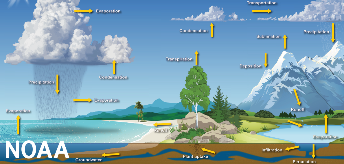
14. Identify the movement of water in the hydrologic cycle, including sources of water, types of precipitation, and causes of condensation.
- Hydrologic cycle – the cycling of water on Earth which can be described with nine major physical processes which form a continuum of water movement; water cycle
- Evaporation – occurs when the physical state of water is changed from liquid to gas
- Solar radiation, air temperature, vapor pressure, wind, and atmospheric pressure affect the amount of natural evaporation that takes place
- Some vapor always exists in the atmosphere
- Condensation – the process by which water vapor changes its physical state from a vapor to a liquid (most commonly)
- Condenses to form dew, fog, or clouds
- Brought about by the cooling of air or by increasing the amount of vapor in the air to its saturation point
- Precipitation – the process that occurs when any and all forms of water particles fall from the atmosphere and reach the ground
- Coalescence – a falling water drop leaves behind a turbulent wake which allows smaller drops to fall faster and to be overtaken to join and combine with the lead drop
- Ice-crystal process – occurs when ice develops in cold or high altitude cloud formations; when water droplets approach the crystals, some droplets evaporate and condense on the crystals until they grow to a critical size and drop as snow or ice pellets
- Precipitated water may onto land or into a body of water
- Rain – Widely spaced drops of liquid water (0.02 inches or larger)
- Drizzle – uniform precipitation composed exclusively of fine drops very close together that fall to the ground
- Sleet – transparent or translucent round or irregularly shaped hard grains of ice consisting of frozen raindrops or melted and refrozen snowflakes (ice pellets)
- Snow – frozen crystalline precipitation that is mostly branched and in the form of six-pointed stars
- Snow grains – very small, white, and opaque grains of ice (frozen drizzle)
- Hail – small balls or other pieces of ice falling separately or frozen together in irregular lumps; associated with thunderstorms; individual stones are 0.25 inches or greater in diameter
- Small hail – white opaque grains of ice that are round or sometimes conical with diameters of less than 0.25 inches (snow pellets)
- Ice crystals – precipitation that generally occurs in very cold regions that consists of falling crystals of ice in the form of needles, columns, or plates (diamond dust)
- Rain – Widely spaced drops of liquid water (0.02 inches or larger)
- Interception – the process of interrupting the movement of water in the chain of transportation events leading to streams
- Can take place by plant cover or storage in puddles or land formations
- The highest level of interception occurs when it snows on conifer forests and hardwood forests that have not yet lost their leaves
- Infiltration – the physical process involving the movement of water through the boundary area where the atmosphere interfaces with the soil
- Water transfer is related to the porosity of the soil and the permeability of the soil profile
- Percolation – the movement of water through soil and its layers by gravity and capillary forces
- Vadose water – water that is in the zone of aeration where air exists
- Groundwater – water that is in the zone of saturation
- All groundwater originates as surface water
- Aquifer – a geologic formation which transmits water from one location to another in sufficient quantity for economic development
- Spring – a place where the water table reaches the ground surface
- Transpiration – a biological process that occurs mostly during the day; water inside of plants is transferred to the atmosphere as water vapor through numerous individual openings in the leaves
- Plants transpire to move nutrients to the upper portion of plants and to cool the leaves that are exposed to the sun
- Strongly affected by the amount of light to which the plant is exposed and the species of plants that are in the soil
- Runoff – flow from a drainage basin or watershed that appears in surface streams; generally consists of the flow that is unaffected by artificial diversions
- Flow is made up of precipitation that falls directly on the stream, surface runoff, subsurface runoff, and groundwater runoff
- Storage – can take place in the atmosphere, on the surface of Earth, or in the ground
- Water in the atmosphere is renewed every 16 days
- Soil moisture is replaced about every year
- Waters in wetlands are replaced about every five years
- Lake water is replaced about every 17 years
- Groundwater renewal can exceed 1400 years in areas of low development by society
- Evaporation – occurs when the physical state of water is changed from liquid to gas
|
15. Analyze ways in which earth and water interact (e.g., soil absorption, runoff, leaching, groundwater, karst topography).
- Soil absorption – the absorption of water by the soil; greatly influenced by soil texture and structure
- Soil texture and structure greatly influence water infiltration, permeability, and water holding capacity
- Soil texture – the composition of the soil in terms of the proportion of small, medium, and large particles (clay, silt, sand) in a specific soil mass
- Coarse soil – sand or loamy sand
- Medium soil – loam, silt loam, or silt
- Fine soil – sandy clay, silty clay, or clay
- Soil structure – the arrangement of soil particles into stable units (aggregates) which give soil its structure
- Aggregates can be loose and friable or form distinct uniform patterns
- Granular structure – loose and friable
- Blocky structure – six sided and can have angled or rounded sides
- Platelike structure – layered and may indicate compaction problems
- Aggregates can be loose and friable or form distinct uniform patterns
- Soil porosity – the space between soil particles which consist of various amounts of water and air
- Depends on both soil texture and soil structure
- Water infiltration – the movement of water from the soil surface into the soil profile
- Texture, structure, and slope have the largest impact on the rate of infiltration
- Water moves by gravity into the open pore spaces in soil
- Permeability – refers to the movement of air and water through the soil
- Affects the supply of root-zone air, moisture, and nutrients available for uptake by plants
- Water-holding capacity – the amount of water than can be held within the soil; controlled primarily by soil texture and organic matter
- Soil texture – the composition of the soil in terms of the proportion of small, medium, and large particles (clay, silt, sand) in a specific soil mass
- Runoff – water “running off” the land surface
- When water hits saturated or impervious ground it begins to flow overland downhill
- As the population increases, more of the natural landscape is replaced by impervious surfaces
- Reduces infiltration of water into the ground
- Accelerates runoff to ditches and streams
- Increases runoff volumes
- Shortens runoff times
- Can cause chemicals and waste to infiltrate surface water and groundwater
- As the population increases, more of the natural landscape is replaced by impervious surfaces
- Will flow along channels as it moves into larger creeks, streams, and rivers
- Can deposit sediment into bodies of water
- When water hits saturated or impervious ground it begins to flow overland downhill
- Leaching – the process of water carrying soluble substances or small particles through soil or rock
- Chemical interactions with surfaces and physical movement of water
- Agricultural ecosystems – leaching is an important balance between salt accumulation and removing nutrients from soils
- Excessive leaching can flush nutrients (especially nitrate and phosphate) from the soil
- Has the potential to affect groundwater and lakes
- Can affect weathered rocks and bedrock by leaching elements from the rocks through dissolution and oxidation
- Dissolution of sedimentary rocks (especially calcium carbonate rocks like limestone) can lead to erosion and sinkholes
- Groundwater – water held below Earth’s surface
- Streams gain water from inflow of groundwater through the streambed; streams lose water by outflow through the streambed; can do both depending on the location of the stream
- Groundwater and surface water physically overlap at the groundwater/surface water interface through the exchange of water and chemicals
- Karst topography – a type of landscape where the dissolving of the bedrock has created sinkholes, sinking streams, caves, springs, and other characteristic features
- Associated with soluble rock types (limestone, marble, gypsum)
- Forms when much of the water falling on the surface interacts with and enters the subsurface through cracks, fractures, and holes that have been dissolved in the bedrock; this water is discharged from springs (many of which are cave entrances)
- Sinkholes – a depression or hole formed when the land surface sinks due to underground bedrock dissolution or cave collapse
- About 20% of the United States is underlain by karst topography and 40% of groundwater used for drinking comes from karst aquifers
16. Identify various forms of water storage (e.g., aquifers, reservoirs, watersheds).
- Aquifers – a groundwater reservoir; can store and release large amounts of subsurface water
- Recharge areas – the watersheds of groundwater reservoirs; surface waterbodies and groundwater are often interconnected in these areas
- Reservoirs – manmade lakes created when a dam is built on a river or over the outlet to a lake
- Valley-dammed reservoirs – the largest and most common type of reservoir; contained by the walls of a valley
- A large dam is built and water from the river is diverted into the reservoir until it is filled; Can take years to complete
- Can change entire ecosystems and caused decreased water levels in other natural sources
- Bank-side reservoirs – reservoirs made by diverting water from a river or other body of water into an existing reservoir
- The existing reservoir has high embankments and usually has a circumference of more than 3.7 miles
- Fewer geographical requirements than with a valley-dammed reservoir
- Water stays in the reservoir for several months and the amount of water pollution is reduced
- Service reservoirs – a reservoir that is completely man-made; can be built into the ground or above ground
- Must have a higher elevation than the area they are servicing in order for the water to flow where it needs to go
- Contains water that has been purified at a water treatment plant before being stored
- Cistern – a service reservoir that is entirely underground
- Valley-dammed reservoirs – the largest and most common type of reservoir; contained by the walls of a valley
- Watersheds – the land area that drains into a body of water
- The watershed of most lakes and rivers is made up of a network of streams, wetlands, human-made channels, storm drains, and the surrounding upland
- The watershed of most lakes and rivers is made up of a network of streams, wetlands, human-made channels, storm drains, and the surrounding upland
17. Analyze interactions between the atmosphere, geosphere, hydrosphere, biosphere, and cryosphere and the effects of these interactions.
- Atmosphere – all the gases surrounding Earth
- Geosphere – all the rock on Earth
- Hydrosphere – all the water on Earth
- Biosphere – all the living things on Earth
- Cryosphere – all the ice on Earth
- Interactions between the spheres affect Earth’s systems and processes; are constantly changing each other
- Ocean currents (hydrosphere) affect air temperature (atmosphere)
- Erosion happens in the desert when wind (atmosphere) shapes the sand (geosphere); water (hydrosphere) can also shape the land, such as in the formation of canyons
- Geosphere and hydrosphere provide the habitat for the biosphere